Visual Basic Softwares:
VB softwares encoded for surface generation,
3D modeling, hydrologic modeling of the wadi catchments in arid lands, and for lineament detection/analysis. Surface building
and rendering softwares enable interactive setting of the contouring intervals, zooming, vertical exaggeration, scale,
legend, veiw frames, text labels, inclination and tilt of the camera and the light source, and variuos options can be
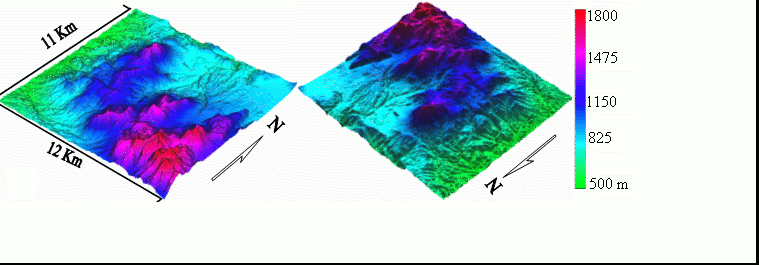
easily managed. Snapshots from the graphical user interfaces and some of the produced models are shown below.
GEOSURFER generates and visualizes
surfaces utilizing xyz data. Surfaces produced can be topographical, geological, environmental, or any spatial surfaces.
GEOMAPPER models and visualizes the
surface/subsurface geology in the 3D space domain.
LinDA for automated Lineament Detection and Analysis from various
remote sensing imageries and Digital Elevation Models (DEMs). Detection of line segments is based on local tonal and shade
variations. DEM is used to judge the nature of the detected segment either a valley or ridge segment. Segments located
in valleys commonly represent structural features in weak zones and the extent of these segments are strong candidate
target for natural resources (water, hydrocarbons, ore deposits, geothermal energy,.....,etc.) exploration and hazard
(earthquakes, landslides,..,etc.) mitigation programs. Analysis involves an expert classification based
on if-then rules using length and orientation criteria, rose diagram generation (number and length), density mapping, grouping
to long lineaments to enhance the tectonic significance, fault-style modeling (strike and dip estimation), and smooth BSpline
representation of lineaments to simulate with unprecedented accuracy the structural features shown on common geologic
maps.
0mm 0pt" class=MsoNormal align=left>
ILTA for Interactive Lineament Tracing
and Analysis. ILTA ia a user-friendly stand-alone program that can interactively enable on-screen digitization of line
segments from any sort of digitial images and formats in addition to those scanned from paper-based geological maps. Once
line segments are picked up, spatial and directional analysis can be easily performed with few clicks (as shown above
in LinDA).
SCS Hydrograph Calculator automates the
process of calculating the hydrograph ordinates and catchment runoff modeling. It was encoded primarily for assessing the
potential of flash floods and artificial recharging for 103 sub-catchments in the wadi systems of Southern
Sinai Egypt. SCS Hydrograph Calculator
Arabized Softwares:
In order to support and enhance the interoperability of the freely-available
GIS softwares, arabization efforts were provided to the worldwide leading Geographic Information Systems "GRASS GIS" as well as the Virtual Terrain Project softwares.